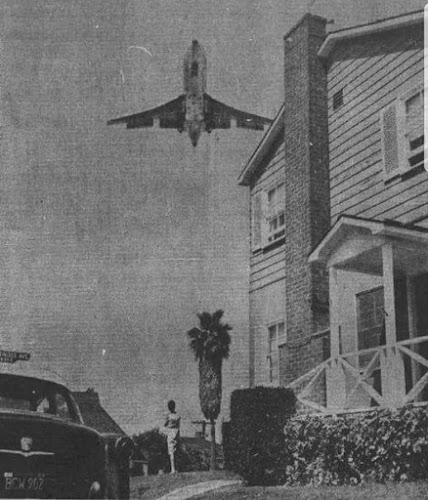
“If you lived in Surfridge prior to the late 1950s, you had to raise your voice a bit when having a conversation.
After the jets came, you had to literally stop talking when they took off,” said Duke Dukesherer,
a business executive who has written about Surfridge’s history.
In the 1960s and 1970s, the area was condemned and acquired by the City of Los Angeles in a
series of eminent domain purchases to facilitate airport expansion and to address concerns about
noise from jet airplanes. Homes were sold, and some went to auction.
All homeowners were forced to sell their property to the City and soon, it was all but abandoned.
Several homeowners sued the City and remained in their houses for several years after
the majority of houses were vacated.
Partially demolished houses during the 1970s
But it was not pleasant.
Eventually all the houses were either moved or demolished.
Some of the streets are still here. Maybe you remember the names? Rindge, Jacqueline,
Kilgore? But sadly, no cars have passed over them in over 25+ years.
The cement is cracking and no one is even allowed to walk them.
Knee-high weeds breach the asphalt, running in lines like lane strips and
foundations still stick out of the ground.
A few old, globeless lampposts are the last standing pieces of a beachfront community wiped from the map.
Reminding us of a time past…
Today, every home is gone, nearly 800 razed to nothing but a few low retaining walls.
Going there, you see only barbed-wire fences protecting vacant land and old streets
where houses once sat and lives were once lived.
A once thriving, populated and vibrant beach colony is now only a ghost town, a fading memory.
Most people in L.A. have no idea it ever even existed.
Broken streets, a park and a butterfly preserve are all that remain of a neighbourhood that
once stood under the flight paths of LAX take-offs. The area is now the protected habitat
New Section 1 Page 21
once stood under the flight paths of LAX take-offs. The area is now the protected habitat
for the endangered El Segundo blue butterfly.
And speaking of the butterfly…
El Segundo blue is a federally designated endangered species butterfly local to a small
dune ecosystem in Southern California that used to be a community called Palisades del Rey,
close to the Los Angeles International Airport (LAX).
In 1986, the airport created the Dunes Restoration Plan to return the dunes to their
original occupants, the El Segundo Blue Butterfly—the first insect designated as an
endangered species in 1973. The butterflies survive on coastal buckwheat that grows
on 200 of the 300 acres of the remaining undeveloped land adjacent to the airport.
The El Segundo Blue Butterfly Habitat Preserve next to LAX exists to protect the species.
There are only three extant colonies of this tiny butterfly still in existence.
The largest of these is on the grounds of LAX; a further colony exists on a site
within the huge Chevron El Segundo oil refinery complex, and the smallest colony
is an area of only a few square yards on a local beach.
The main threat the Blue Butterfly faces is the destruction to its habitat.
This is caused by the urbanization and industrialization of the LAX and the
company Chevron for removing the butterfly’s host plant, buckwheat.
But back to the neighbourhood…
In the screenshots below, you can see the neighboruhood streets,
and where the airport is in relation.
I have to admit, I wouldn’t want to live there now.
In the front of the abandoned cities is Dockweiler State Beach. It has 3.75 miles (6.04 km)
of shoreline and a hang gliding training area. Although a unit of the California state park system,
it is managed by the Los Angeles County Department of Beaches and Harbours.
You can also camp there as it has an RV Park as well.
Dockweiler State Beach RV Park. It is described this way on Wikipedia:
“Dockweiler State Beach is in the Playa del Rey neighborhood at the western terminus
of Imperial Highway. Between the beach and the airport lies the ghost town of Palisades del Rey.”
The park also boasts the Dockweiler Beach Hang Glider Flight Training Park,
where beginners can learn the sport of hang gliding. Students launch off 25-foot-high (7.6 m) dunes.
The facility was built by the city and county and is operated by concession WindSports.
Literary Mention: There’s a weird/sexy encounter in an abandoned Surfridge house in
Thomas Pynchon’s LA-at-the-end-of-the-’60s novel Inherent Vice but other than that
and the strange abandoned roads you see as you take off from LAX,
just a few photographs and postcards remain,


